|
 The
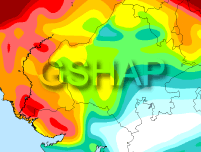
map on this page display the seismic hazard for south
Asia and were developed using the GSHAP dataset. GSHAP or the
Global Seismic Hazard Assessment Program was launched in 1992 by the
International Lithosphere Program (ILP) with the support of the
International Council of Scientific Unions (ICSU), and endorsed as a
demonstration program in the framework of the United Nations
International Decade for Natural Disaster Reduction (UN/IDNDR). The
primary goal of GSHAP was to create a global seismic hazard map in a
harmonized and regionally coordinated fashion, based on advanced
methods in probabilistic seismic hazard assessments.
Available
databases and information
has been utilized by the ASC to generate the following maps
using the freely available
Generic Mapping Tools (GMT)
software. These maps may be reproduced in print or
electronically without removing the ASC's embedded link. The
map on this page display the seismic hazard for south
Asia and were developed using the GSHAP dataset. GSHAP or the
Global Seismic Hazard Assessment Program was launched in 1992 by the
International Lithosphere Program (ILP) with the support of the
International Council of Scientific Unions (ICSU), and endorsed as a
demonstration program in the framework of the United Nations
International Decade for Natural Disaster Reduction (UN/IDNDR). The
primary goal of GSHAP was to create a global seismic hazard map in a
harmonized and regionally coordinated fashion, based on advanced
methods in probabilistic seismic hazard assessments.
Available
databases and information
has been utilized by the ASC to generate the following maps
using the freely available
Generic Mapping Tools (GMT)
software. These maps may be reproduced in print or
electronically without removing the ASC's embedded link. |