|
 State
- Manipur, India State
- Manipur, India
Capital
- Imphal
Population
-
2,388,634 (2001)
Population per
district (Top 5)
Imphal West
- pop. 444,382
Imphal East - pop.
394,876
Thoubal - pop.
364,140
Churachandpur - pop.
227,905
Senapati - pop. 156,513
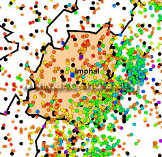
Earthquake History
Earthquakes of
low to moderate intensity are recorded here regularly. The state of
Manipur, has weathered dozens of large earthquakes the biggest in
recent times being the 1988 M7.2 earthquake.
Most earthquakes in western Manipur are shallow. But some, especially
those recorded in the eastern parts and along and across the Myanmar
border have greater depths. Areas in central Manipur are especially
vulnerable to damage during earthquakes as they lie in the Imphal
Valley, the lowest point of which lies the Logtak Lake. Much of the
valley floor provides for strong shaking from even far off quakes as
its soft soil amplifies the wave motions.
Seismic Hazard
All districts of the state of
Manipur lie in Zone V.
Since the earthquake database in India is still
incomplete, especially with regards to earthquakes prior to the historical
period (before 1800
A.D.), these zones offer a rough guide of the
earthquake hazard in any particular region and need to be regularly updated
(See also:
GSHAP Hazard Map for Manipur).
Largest Instrumented
Earthquake in
Manipur
18 May 1987 - Near Karong, Northern Manipur,
Ms 6.2 (PEK)
01:53:51.0 UTC, 25.2287N, 94.2076E, 52.80kms depth
Significant
Earthquakes in
Manipur
The following list briefly outlines known earthquakes in this region. General locations are provided for historical events for
which "generalized" epicentral co-ordinates are available.
Some events which were significant for other reasons are also included.
This list will be updated whenever newer information is available. Please note
that Magnitude and Intensity are NOT THE SAME. All events are within the state
or union territory covered on this page unless stated otherwise.
Acronyms Used:
D=Depth,
OT=Origin
Time, Mw=Moment
Magnitude, Ms=Surface
Wave magnitude,
Mb=Body
Wave Magnitude, ML=Local
Magnitude, M?=Magnitude
Type unknown
|
This listing will be modified
without notice. Please check back for the latest version
when using it elsewhere.
Additionally, please
reproduce using appropriate
CITATIONS/CREDITS. |
18 August 1926 - East of Palel,
Manipur (Indo-Myanmar Border region), 6.0 (TS)
23:58:48 UTC, 24.50N, 94.50E
15 March 1927 - East of Thaungd,
Sagaing Division (Indo-Myanmar Border region), 6.5 (TS)
16:50:32 UTC, 24.50N, 95.00E
20 May 1927 - Near Kangpat, Manipur
(Indo-Myanmar Border region) , 6.0 (TS)
10:51 UTC, 24.50N, 94.50E
11 July 1930 - North of Imphal,
Manipur, 6.0 (TS)
07:06:34 UTC, 25.00N, 93.80E
22 September 1930 - Near Karong,
Manipur, 6.0 (TS)
14:19:14 UTC, 25.30N, 93.80E
2 June 1934 - East of Ukhrul,
Manipur (Indo-Myanmar Border region), 6.5
(TS)
05:04:27 UTC, 25.10N, 94.70E
23 April 1935 - East of Ukhrul,
Manipur (Indo-Myanmar Border region), 6.0
(TS)
16:45:41 UTC, 25.10N, 94.70E
9 September
1937 - East of Ukhrul, Manipur
(Indo-Myanmar Border region), 6.0
(TS)
23:37:27 UTC, 24.90N, 94.70E
6 May 1938 -
East of Ukhrul, Manipur (Indo-Myanmar Border region),
6.5 (TS)
03:40:57 UTC, 24.90N, 94.70E
21 March 1937 - SW of Kohima (Manipur-Nagaland Border
region), 6.0 (TS)
16:12:02 UTC, 25.50N, 94.00E
27 May 1939 - South of Palel, Manipur, 6.7 (TS)
03:45:37 UTC, 24.30N, 94.10E
11 May 1940 - Near Imphal, Manipur, 6.0 (TS)
21:00:19 UTC, 24.90N, 94.10E
8 March 1947 - East of Imphal (Indo-Myanmar Border region),
6.0 (TS)
14:33:05 UTC, 24.90N, 94.70E
30 April 1952 - SE of Kohima (Manipur-Nagaland Border
region), 6.0 (TS)
01:49:?? UTC, 25.500N, 94.500E
7 November 1952 - SW of Kohima (Manipur-Nagaland Border
region), 6.0 (TS)
04:33:57 UTC, 25.500N, 94.000E
1 July 1957 - Near Moirang, Southern Manipur, 7.25 (TS)
19:30:22 UTC, 24.400N, 93.800E
30 September 1983 - East of Ukhrul, Manipur (Indo-Myanmar
Border region), Mb 6.0 (BKK)
10:39:27.0 UTC, 25.0393N, 94.6695E, 60.3kms depth
5 March 1984 - East of Palel, Manipur (Indo-Myanmar Border
region), Mb 6.2
(HFS)
21:26:42.0 UTC, 24.5160N, 94.6204E, 67.50kms depth
6 May 1984 - NE of Aizwal (Manipur-Mizoram Border region),
Mb 6.0 (HFS)
15:19:11.0 UTC, 24.2152N, 93.5256E, 31.60kms depth
18 May 1987 - Near Karong, Northern Manipur,
Ms 6.2 (PEK)
01:53:51.0 UTC, 25.2287N, 94.2076E, 52.80kms depth
6 August 1988 - East of Imphal
(Indo-Myanmar Border region), Mw 7.2 (HRV)
00:36:24.6 UTC, 25.149N, 95.127E, 91 kms depth
Three people were killed in this earthquake. Tremors were felt over much of eastern and north-eastern
India, Bangladesh, Bhutan, Eastern Nepal and Myanmar. Felt as far as Kolkata and Patna. Some damage was also reported from Homalin
in northern Myanmar.
15 April 1992 - NW of Mawalik, Chin Division (Indo-Myanmar
Border region), Mb 6.3 (HFS)
01:32:11.0 UTC, 24.2680N, 94.9275E, 130.90kms depth
18 September 2005 -
Myanmar-Manipur border, Mw 5.7
24.653 N, 94.807 E, D=82 kms, OT=07:26:00 UTC
A
moderate earthquake struck
the Myanmar-Manipur border, on
18 September 2005 at 12:56 IST causing isolated
minor damage to property in some parts of Manipur.
The earthquake had a magnitude of
Mb=5.7 and was felt at many places
north-east India and Bangladesh as well as in
tall buildings in northern Thailand.
4 September 2009 -
Myanmar-Manipur border, Mw 5.9
24.381 N, 94.712 E, D=97.6 kms, OT=19:51:03 UTC
A
moderate earthquake struck
the Myanmar-Manipur border, on 4 September 2009
at 01:21 IST. It was felt widely in
north-east India and in Bangladesh.
|