|
 State
- Himachal Pradesh, India State
- Himachal Pradesh, India
Capital
- Shimla
Population
-
21,082,989 (2001)
Population per
district (Top 5)
Kangra
- pop. 1,339,030
Mandi - pop.
901,344
Shimla - pop. 722,502
Solan - pop. 500,557
Chamba - pop.
460,887
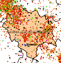
Earthquake History
The state of
Himachal Pradesh lies almost entirely in the Himalayan mountains, and
is part of the Punjab Himalayas. Due to its location it weathers
dozens of mild earthquakes every year. Large earthquakes have occurred
in all parts of Himachal Pradesh, the biggest being the Kangra
Earthquake of 1905. The Himalayan Frontal
Thrust, the Main boundary Thrust, the Krol, the Giri, Jutogh and Nahan
thrusts lie in this region. Besides that there are scores of smaller
faults, like the Kaurik Fault which triggered the 1975 earthquake.
However, it must be stated that
proximity to faults does not necessarily translate into a higher
hazard as compared to areas located further away, as damage from
earthquakes depends on numerous factors such as subsurface geology as
well as adherence to the building codes.
Seismic Hazard
Chamba, Kullu, Kangra, Una, Hamirpur,
Mandi, and Bilaspur Districts lie in Zone V. The remaining districts of Lahual
and Spiti, Kinnaur, Shimla, Solan and Sirmaur lie in Zone IV.
Since the earthquake database in India is still
incomplete, especially with regards to earthquakes prior to the historical
period (before 1800
A.D.), these zones offer a rough guide of the
earthquake hazard in any particular region and need to be regularly updated
(See also:
GSHAP Hazard Map for Himachal Pradesh).
Largest Instrumented
Earthquake in Himachal Pradesh
4 April 1905 -
Kangra
(Himachal Pradesh), Mw 7.8
33.00
N , 76.00
E, OT=00:50 UTC
At leats 28,000 people were killed in the
Kangra-Dharamsala region of Himachal Pradesh. Damage and casualties
also occurred in adjoining parts of Punjab including in the cities
of Amritsar, Lahore, Jalandhar, Ludhiana and Sialkot.
Significant
Earthquakes in
Himachal Pradesh
The following list briefly outlines known earthquakes in this region. General locations are provided for historical events for
which "generalized" epicentral co-ordinates are available.
Some events which were significant for other reasons are also included.
This list will be updated whenever newer information is available. Please note
that Magnitude and Intensity are NOT THE SAME. All events are within the state
or union territory covered on this page unless stated otherwise.
Acronyms Used:
D=Depth,
OT=Origin
Time, Mw=Moment
Magnitude, Ms=Surface
Wave magnitude,
Mb=Body
Wave Magnitude, ML=Local
Magnitude, M?=Magnitude
Type unknown
|
This listing will be modified
without notice. Please check back for the latest version
when using it elsewhere.
Additionally, please
reproduce using appropriate
CITATIONS/CREDITS. |
4 April 1905 -
Kangra
(Himachal Pradesh), Mw 7.8
33.00
N , 76.00
E, OT=00:50 UTC
At leats 28,000 people were killed in the
Kangra-Dharamsala region of Himachal Pradesh. Damage and casualties
also occurred in adjoining parts of Punjab including in the cities
of Amritsar, Lahore, Jalandhar, Ludhiana and Sialkot.
28 February 1906 - Near
Kullu (Himachal Pradesh), Mw 6.4
32.00N, 77.00E
Damage and casualties in the Bashahr-Shimla hills
states.
11 May 1930 - East of Sultanpur (Himachal Pradesh), 6.0 (TS)
11:30:36 UTC, 31.70N, 77.00E
22 June 1945 - Near Padua, Kathwa District, J&K (H.P.-J&K
Border region), 6.0 (TS)
18:00:51 UTC, 32.599N, 75.90E
10 July 1947 - Near Padua, Kathwad District, J&K (H.P.-J&K
Border region), 6.0 (TS)
10:19:20 UTC, 32.599N, 75.90E
12 August 1950 - Near Padua, Kathwad District, J&K (H.P.-J&K
Border region), 6.0 (TS)
03:59:06 UTC, 32.599N, 75.90E
12 September 1951 - Chamba-Udhampur Districts (H.P.--J&K
Border region), 6.0 (TS)
20:41:48UTC, 33.30N, 76.50E
17 June 1955 - Lahual-Spiti District (Himachal Pradesh), 6.0
(TS)
10:14:09UTC, 32.50N, 78.60E
17 June 1962 - Chamba-Udhampur Districts (Himacahl
Pradesh-J&K Border region), 6.0 (TS)
04:39:26.60 UTC, 33.30N, 76.20E
19 January 1975 - SW of Dutung,
Himachal Pradesh (Indo-China Bdr region), Ms
6.8 (NEIC)
08:02:02.50, 32.455N, 78.430N, 33kms depth
This earthquake struck in the early afternoon of January 19, 1975.
It registered 6.2 on the Richter Scale. It caused havoc in parts of
the Kinnaur, Lahaul and Spiti regions of India.
60 people were killed in this sparsely populated region.
21 October 1991
- Near Pilang (Uttarkashi District), Uttaranchal,
Mw 6.8 (NEIC)
21:23:14 UTC /
02:53:14 IST, 30.78N, 78.77E
Between 750 to
2000 people killed in
the Gharwal region. It was also
felt very strongly in Uttar Pradesh, Chandigarh, Delhi, Haryana and
Punjab. Fatalities were also reported from
Himachal Pradesh. Some minor damage was reported in
Chandigarh and New Delhi.
29th March 1999
- Near Gopeshwar (Chamoli District), Uttaranchal,
Mw 6.5 (HRV)
19:05:11 UTC, 30.492N, 79.288E
115 people killed in the Gharwal
region. The quake was felt very strongly
in Uttar Pradesh, Chandigarh, Delhi and Haryana. In Haryana, one
person was killed in the city of Ambala and
2 at Nakodar in the neighbouring state of
Punjab. Minor damage to buildings in New Delhi,
most significantly in Patparganj. Minor damage also reported from
Chandigarh.
11 November 2004 -
Bharmour, Kangra region, Mb 5.1
32.442 N, 76.512 E, D=34 kms, OT=02:13:45 UTC
A moderate
earthquake struck the
Kangra Valley and the Dhauladhar Mountains
on 11 November 2004
at 07:43 AM local time. It was felt
strongly in the Kangra-Dharamsala region and event caused minor
damage to buildings in the region. It had a magnitude of
Mb=5.1.
8 October 2005
-
Kashmir-Kohistan, Pakistan-India border, Mw
7.6
34.432 N, 73.537
E, D=020.0 kms, OT=03:50:40 UTC
A
major earthquake struck the India-Pakistan
border on the morning of 8 October 2005. It had a magnitude of
Mw=7.6 and was felt
strongly in much of Pakistan,
northern India and eastern Afghanistan. The earthquake resulted in
more than 80,000 deaths in northern
Pakistan and adjoining parts of Jammu & Kashmir, India and is by far
one of the deadliest in the sub-continent. At least 10 people also
died in other parts of north India and 4 in Afghanistan due to this earthquake.
Tremors from the earthquake were felt more than a thousand
kilometres away in the Indian states of Gujarat, Madhya Pradesh and
Uttar Pradesh.
|