|
 State
- Punjab, India State
- Punjab, India
Capital
- Chandigarh (U.T.)
Population
-
26,909,428
(2001)
Million+ Cities
Ludhiana
- pop. 1,395,053
Population per
district (Top 5)
Amritsar
- pop. 3,096,077
Ludhiana - pop.
3,032,831
Gurdaspur - pop. 2,104,011
Sangrur - pop.
2,000,173
Jalandhar - pop. 1,962,700
Earthquake History
Punjab lies in a
fore-deep, a downwarp of the Himalayan foreland, of variable depth,
converted into flat plains by long-vigorous sedimentation. This is
known as a geosyncline. This has shown considerable amounts of flexure
and dislocation at the northern end and is bounded on the north by the
Himalayan Frontal Thrust. The floor of the trough (if see without all
the sediments) is not an even plain, but shows corrugated inequalities
and buried ridges (shelf faults). Much of Punjab lies in the Punjab
Shelf, bounded on the east by the Delhi-Haridwar
Ridge and on the south by the Delhi-Lahore Ridge. Most earthquakes in
this region are shallow though a few earthquake of intermediate depth
have been recorded in Punjab.
However, it
must be stated that proximity to faults does not necessarily translate
into a higher hazard as compared to areas located further away, as
damage from earthquakes depends on numerous factors such as subsurface
geology as well as adherence to the building codes.
Seismic Hazard
The districts of Firozpur, Faridkot,
Patiala, Mansa, Sangrur and Bhatinda lie in Zone III. The districts of Amritsar,
Gurdaspur, Hoshiarpur, Jalandhar, Kapurthala, Ludhiana, and Rupnagar lie in zone
IV. Since the earthquake database in
India is still incomplete, especially with regards to earthquakes prior to the
historical period (before 1800 A.D.), these zones offer a rough guide of the earthquake hazard in any
particular region and need to be regularly updated
(See also:
GSHAP Hazard Map for Punjab).
Largest Instrumented
Earthquake in
Punjab
14 October 1970 - North of Firozpur (Indo-Pakistan Border region), 5.2 Mb
(USCGS)
00:36:34.0 UTC, 31.26N,
74.50E, 44 kms depth
Significant
Earthquakes in Punjab
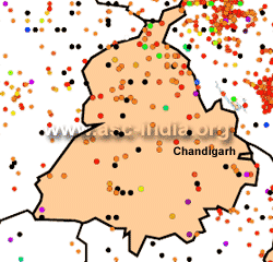
The following list briefly outlines known earthquakes in this region. General locations are provided for historical events for
which "generalized" epicentral co-ordinates are available.
Some events which were significant for other reasons are also included.
This list will be updated whenever newer information is available. Please note
that Magnitude and Intensity are NOT THE SAME. All events are within the state
or union territory covered on this page unless stated otherwise.
Acronyms Used:
D=Depth,
OT=Origin
Time, Mw=Moment
Magnitude, Ms=Surface
Wave magnitude,
Mb=Body
Wave Magnitude, ML=Local
Magnitude, M?=Magnitude
Type unknown
|
This listing will be modified
without notice. Please check back for the latest version
when using it elsewhere. Additionally, please
reproduce using appropriate
CITATIONS/CREDITS. |
4 April 1905 -
Kangra
(Himachal Pradesh), Mw 7.8
33.00
N , 76.00
E, OT=00:50 UTC
At leats 28,000 people were killed in the
Kangra-Dharamsala region of Himachal Pradesh. Damage and casualties
also occurred in adjoining parts of Punjab including in the cities
of Amritsar, Lahore, Jalandhar, Ludhiana and Sialkot.
14 October 1970 - North of Firozpur (Indo-Pakistan Border
region), 5.2 Mb (USCGS)
31.26
N, 74.50 E, D=044.0
kms, OT=00:36:34 UTC,
21 October
1991
- Near Pilang
(Uttarkashi), Uttaranchal, Mw 6.8
30.78
N, 78.77 E, OT=21:23:14
UTC
Between 750 to
2000 people killed in
the Gharwal region. It was also
felt very strongly in Uttar Pradesh, Chandigarh, Delhi, Haryana and
Punjab. Some minor damage was reported in Chandigarh and New Delhi.
17 October 1997
- North of
Jalandhar, Gurdaspur District (Punjab), 5.1 Ms (EIDC)
31.616
N, 75.774 E,
D=38 kms, OT=17:36:31 UTC
29 March 1999
- Near Gopeshwar (Chamoli), Uttaranchal Mw
6.5 (HRV)
30.492 N, 79.288
E, OT=19:05:11 UTC
115 people killed in the Gharwal
region. The quake was felt very strongly
in Uttar Pradesh, Chandigarh, Delhi and Haryana. In Haryana, one
person was killed in the city of Ambala and
2 at Nakodar in the neighbouring state of
Punjab. Minor damage to buildings in New Delhi,
most significantly in Patparganj. Minor damage also reported from
Chandigarh.
8 October 2005
-
Kashmir-Kohistan, Pakistan-India border, Mw
7.6
34.432 N, 73.537
E, D=020.0 kms, OT=03:50:40 UTC
A
major earthquake struck the India-Pakistan
border on the morning of 8 October 2005. It had a magnitude of
Mw=7.6 and was felt
strongly in much of Pakistan,
northern India and eastern Afghanistan. The earthquake resulted in
more than 80,000 deaths in northern
Pakistan and adjoining parts of Jammu & Kashmir, India and is by far
one of the deadliest in the sub-continent. At least 10 people also
died in other parts of north India (including 2
in Punjab) and 4 in Afghanistan due to this earthquake.
Tremors from the earthquake were felt more than a thousand
kilometres away in the Indian states of Gujarat, Madhya Pradesh and
Uttar Pradesh.
14 March 2010
-
Near Hiranagar,
Punjab, Mb=4.5
32.134
N, 75.759 E,
D=58.3 kms OT=06:53:29 UTC
A light
earthquake occurred in northern Punjab
along the Punjab-Himachal Pradesh border
on 14 March 2010 at 12:23 PM
local time in India. It had a magnitude of Mb=4.5 and was
felt over a wide area due to its depth.
|