|
 State
- Mizoram, India State
- Mizoram, India
Capital
- Aizwal
Population
-
891,058
(2001)
State
- Tripura, India
Capital
- Agartala
Population
-
3,191,168
(2001)
Population per
district (largest per state)
West Tripura (Tripura)
- pop. 1,532,982
Aizwal (Mizoram)
- pop.
325,676
Earthquake History
In Mizoram, lie
the southern most end of the Purbachal Himalayan range. Their folded
structure is a synclinorium consisting of broad synclines and
tight-faulted anticlines. Earthquakes in this region are generally
shallow, though a few quakes of intermediate depth have occured. Most
deeper earthquakes occur along and across the international border, in
Myanmar's Chin Division.
Earthquake
activity in Tripura is mainly shallow. The Dauki Fault which follows
the international border of India and Bangladesh in Meghalaya passes
though northern sections of Tripura. The other major threat is from
the Madhupur Fault in Bangladesh. However, it must be stated
that proximity to faults does not necessarily translate into a higher
hazard as compared to areas located further away, as damage from
earthquakes depends on numerous factors such as subsurface geology as
well as adherence to the building codes.
Seismic Hazard
The seismic hazard map of India was
updated in 2000 by the Bureau of
Indian Standards (BIS). Both the
states of Mizoram and Tripura lie entirely in Zone V. Since the earthquake database in
India is still incomplete, especially with regards to earthquakes prior to the
historical period (before 1800 A.D.), these zones offer a rough guide of the earthquake hazard in any
particular region and need to be regularly updated
(See also:
GSHAP Hazard Map for Mizoram & Tripura).
Largest Instrumented
Earthquake in
Mizoram & Tripura
22 November 1997
- Southern Mizoram, Mw
6.1 (NEIC)
11:23:06.0 UTC, 22.212N, 92.702E, 54kms depth
No
fatalities were reported in Mizoram, however, 23 people were killed when a
5-storey building collapsed in Chittagong, Bangaldesh. Tremors wee felt as far
as Rangpur and Rajshahi.
Significant
Earthquakes in
Mizoram & Tripura
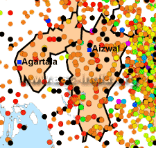
The following list briefly outlines known earthquakes in this region. General locations are provided for historical events for
which "generalized" epicentral co-ordinates are available.
Some events which were significant for other reasons are also included.
This list will be updated whenever newer information is available. Please note
that Magnitude and Intensity are NOT THE SAME. All events are within the state
or union territory covered on this page unless stated otherwise.
Acronyms Used:
D=Depth,
OT=Origin
Time, Mw=Moment
Magnitude, Ms=Surface
Wave magnitude,
Mb=Body
Wave Magnitude, ML=Local
Magnitude, M?=Magnitude
Type unknown
|
This listing will be modified
without notice. Please check back for the latest version
when using it elsewhere. Additionally, please
reproduce using appropriate
CITATIONS/CREDITS. |
15 August 1920
- West of Saitlan, Chin Division (Indo-Myanmar Border region) , 6.0
(TS)
06:59:08 UTC, 22.20N, 93.20E
24 December 1950 - NW of Srimangal, Chittagong Division
(Bangladesh), 6.3 (TS)
22:35:20.10 UTC, 24.40N, 91.70E
12 December
1957 - South
of Silchar, Cachar District (Assam-Mizoram bdr
region), 6.0 (TS)
24.500 93.000
14 November 1967 - NE of Agartala (Indo-Bangladesh Border
region), 5.1 (TS)
00:04:17.80 UTC, 24.00N, 91.50E
27 December 1968 - NE of Agartala (Indo-Bangladesh Border
region), 5.2 (TS)
14:38:11.60 UTC,24.10N, 91.60E
2 February 1971 - East of Agartala (Tripura), Mb5.4 (NEIS),
5.4 (TS)
07:59:57 UTC, 23.80N, 91.80E
21 May 1984 - SE of Agartala (Tripura), Mb 5.3 (NEIS)
09:59:05.0 UTC, 23.6573N, 91.5078E, 12.60 kms depth
30 December 1984
- South of
Silchar (Assam-Mizoram border region), Mw6.0 (HRV)
23:33:37 UTC, 24.64N, 92.89E, 23 kms depth
20 people were killed in Assam's Cachar district. This earthquake
was forecast on the basis of foreshock activity and then the
following quiescience.
13 April 1989 - Tripura-Mizoram-Assam border region, Mb 5.1 (NEIC)
07:25:33.0 UTC, 24.4041N, 92.4312E, 9.90 ksm depth
22 November 1997
- Southern
Mizoram, Mw 6.1 (NEIC)
11:23:06.0 UTC, 22.212N, 92.702E, 54kms depth
No fatalities were
reported in Mizoram, however, 23 people were killed when a 5-storey
building collapsed in Chittagong, Bangaldesh. Tremors wee felt as
far as Rangpur and Rajshahi.
|