|
 State
- Meghalaya, India State
- Meghalaya, India
Capital
- Shillong
Population
-
2,306,069 (2001)
Population per
district (Top 5)
East Khasi Hills
- pop. 660,923
West Garo Hills - pop.
518,390
Jaintia Hills - pop.
299,108
West Khasi Hills
- pop.
296,049
East Garo Hills - pop.
250,582
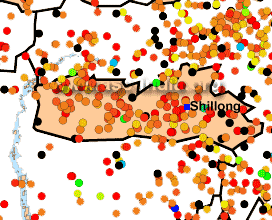
Earthquake History
Nearly all of the
state of Meghalaya, lies on the "Shillong Massif". This is a
block-like structure that has not undergone much folding or faulting
as compared to the surrounding areas. The main threats to the
state come from faults bounding the massif with the surrounding areas.
The northern part of the massif has several faults, among the
newly identified Oldham Fault that is believed
responsible for the 1897 earthquake. The southern boundary is
marked by the east-west trending Dauki Fault, along the Bangladesh
border. Moderate earthquakes have occurred in this state but the most
significant of all was the Great Assam earthquake of 1897. Centred
across the state border in Assam, much of Meghalaya was severely
jolted especially Shillong.
Seismic Hazard
All districts of the state of
Meghalaya lie in Zone V.
Since the earthquake database in India is still
incomplete, especially with regards to earthquakes prior to the historical
period (before 1800
A.D.), these zones offer a rough guide of the
earthquake hazard in any particular region and need to be regularly updated
(See also:
GSHAP Hazard Map for Meghalaya).
Largest Instrumented
Earthquake in
Meghalaya
7 April 1951 - Near Rongrengiri, Meghalaya,
6.8 (TS)
20:29:12.40 UTC, 25.80N, 90.40E
Significant
Earthquakes in Meghalaya
The following list briefly outlines known earthquakes in this region. General locations are provided for historical events for
which "generalized" epicentral co-ordinates are available.
Some events which were significant for other reasons are also included.
This list will be updated whenever newer information is available. Please note
that Magnitude and Intensity are NOT THE SAME. All events are within the state
or union territory covered on this page unless stated otherwise.
Acronyms Used:
D=Depth,
OT=Origin
Time, Mw=Moment
Magnitude, Ms=Surface
Wave magnitude,
Mb=Body
Wave Magnitude, ML=Local
Magnitude, M?=Magnitude
Type unknown
|
This listing will be modified
without notice. Please check back for the latest version
when using it elsewhere.
Additionally, please
reproduce using appropriate
CITATIONS/CREDITS. |
12 June 1897 -
Near Rangjoli, Assam, Mw 8.0
26.00N, 91.00E
Close to 1,500 people were killed and hundreds
injured. Heavy damage occurred in most parts of Meghalaya and Assam.
Damage occurred as far as Kolkata, Dhaka and eastern Bihar. Tremors
were felt over a wide section of India.
9 September 1923 - West of Durgapur,
Dhaka Division (Indo-Bangladesh Bdr.), 7.1
(TS)
22:03:42 UTC, 25.25N, 91.00E
2 July 1930 - South of Dhubri, Assam (Meghalaya - Assam
Border region), 7.1 (TS)
21:03:34.4 UTC, 25.80N, 90.20E
Heavy damage occurred in Dhubri. No fatalities
were recorded for this earthquake, despite the fact that it occurred
late at night.
27 March 1932 - North-west of Jowai, Meghalaya, 6.0 (TS)
08:48:45 UTC, 25.50E, 92.50N
19 May 1945 - Near Mohanganj, Dhaka
Division (Indo-Bangladesh bdr.
region) 6.0 (TS)
05:02:53 UTC, 25.10N, 90.90E
7 April 1951 - Near Rongrengiri, Meghalaya,
6.8 (TS)
20:29:12.40 UTC, 25.80N, 90.40E
|